Location-based applications

An increasing number of people carry cameras, PDAs, cell phones, and GPS devices that can sense their current location. That enables location-based applications like finding nearby friends, addresses and businesses, getting directions, local ads, emergency notification, finding lost or stolen items, tracking delivery vehicles and taxis, etc. Of course there are also military and even terrorist applications.

Location-based applications often involve mashups. For example,

  • http://www.fundrace.org/ combines data from the Federal Election Commission with Google Maps. Other mashups allow one to trace and measure routes, for example: The government compiles geocodes, latitude and longitude, for addresses. You can find geocodes at Geocoder, Geocode, or Mapbuilder which calls Geocoder. Mapalist.com will generate geocodes for a list of addresses in a Google spreadsheet.

    One can also make a rough guess of the location of a computer based on its IP address. You can convert IP addresses to city or region names at Geobytes.com or HostIP.com. They also offer simple scripts for mentioning the user's location when they visit your Web site.

    If you have the latitude and longitude of a location, you can jump directly to it in Google Maps by entering the coordinates into the search box.

    For mobile applications, your latitude and longitude can be determined using the Global Positioning System (GPS) or other radio-based mean like finding the distance to nearby cell towers. To provide wireless 911 service, the FCC has mandated location-awareness for cell phones. While the entire nation is not yet covered, location-aware cell phones will eventually be ubiquitous.

    Vendors are beginning to ship phones with location-based applications. Here we see Nokia's applications built using their own mapping system:
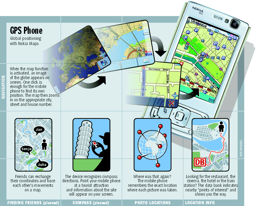
    Phones running Google's Android operating system will also feature applications based on Google Maps.

    For more on this topic see:

    Google. Microsoft and Yahoo are compiling global databases of street maps and map services which can be incorporated into applications. They are also adding images to their maps. Here, for example, is a Google Map view of the Disney Concert Hall in downtown Los Angeles.

    Disclaimer: The views and opinions expressed on unofficial pages of California State University, Dominguez Hills faculty, staff or students are strictly those of the page authors. The content of these pages has not been reviewed or approved by California State University, Dominguez Hills.